Atlantic hurricanes of the Twentieth Century were relatively kind to Georgia. Those of the Nineteenth Century were much deadlier. Deadly hurricanes struck the Georgia coastline head on in 1804, 1813, 1824, 1854, 1881, 1893, and 1898. The 1854 storm has been estimated to have been a Category 3 hurricane. The latter storm packed one of the biggest punches, striking between Cumberland and St. Simons Islands, killing nearly 200 people. In 1989, Hurricane Hugo was headed for a direct hit on Savannah, destined to die out in eastern Central Georgia. The storm turned to the northwest and devastated Charleston and Charlotte in the Carolinas. The storm of October 2nd and 3rd of 1898 moved northwesterly through southeast Central Georgia, including the lower portion of Laurens County before becoming a tropical storm. That made it the only known hurricane to strike Laurens County, which is located more than one hundred miles inland.

On August 27, 1881, a hurricane struck the coast of Georgia, killing an estimated seven hundred persons. The book "History of Laurens County, Georgia, 1807-1941" states that a catastrophic hurricane moved northeasterly across the southern part of Laurens County in 1882 causing major damage to a wide belt of primeval pine trees. It was said that for many years the area was a wasteland of great clay roots. No newspaper references to this storm have been found to corroborate this storm. Except for the direction of the storm, the event could have occurred during the hurricane of August 27, 1881. The "Dublin Post" reported: "The heavy wind and rain storm which lasted from Saturday night to Monday morning worked untold ruin on the cotton crop. All open cotton was beaten out, and the young stalk often blown or beaten down."
Exactly twelve years later, another hurricane hit Georgia's coastline. This storm, which killed an estimated one thousand to twenty five hundred persons, is considered America's third worst natural disaster and the twentieth deadliest Atlantic hurricane in the second half of the second millennium, A.D.. The 1893 storm came up from the southeast hitting Savannah and then Charleston and probably did not impact Laurens County, which would have been on the weaker, eastern end of the storm. Six weeks later, a hurricane killed two thousand or more people in Louisiana. The 1881 storm is estimated to have been the fifth deadliest hurricane in American history. The deadliest storm in American history occurred just over a century ago when eight to twelve thousand people were killed in Galveston, Texas on September 8, 1900.
In October of 1894, a hurricane struck northeast Florida and crossed
into southern and central Georgia, and became a a tropical storm. There
is no real data to indicate if the storm was a full hurricane strength as it
passed near Laurens County.

The moon had been full on September 29. 1898. Horace Gould, of St. Simons Island, reported that the wind had been blowing steadily out of the northeast for three days prior to the arrival of the storm. The "northeaster" added to the water level in the marshes and estuaries, which is normally higher in October along the Georgia Coast. The storm struck late in the evening of the 2nd, One hundred and 18 years ago this week. (2016) The inhabitants of St. Catherine's, Campbell, Butler, Wolf, and Chapney Islands to the north of St. Simons Island suffered the most damage - being on the deadly northeastern edge of the storm. All but one person on St. Catherine's was killed. All fifty something residents of Campbell Island were washed away in the storm surge. A little to the south, residents of Darien reported that the storm surge was thirteen feet high.
J.A. Falk, assistant superintendent of the Jekyll Island Club, reported that "we had the most severe storm ever known here - it was a tidal wave." The dunes along the beach were washed away. The fisherman's houses and the northern and southern ends of the island were washed away. The village of millionaire's cottages survived the storm virtually unharmed, despite the fact that the entire island was covered with water and many oaks were blown down.
Cumberland Island, now thought to be the site of the landfall of the eye of the hurricane, was subjected to vicious winds, heavily rainfall, and a high storm surge. Frank Fader's pilot boat was found on a bluff twenty feet above the high water level. Many homes, especially along the northern end of the island, were destroyed.
Fernandina Island, to the south, was completely covered with water. Almost everything not tied down was swept away. Not a single church in Old Town Fernandina survived the onslaught.
 Most of the city of Brunswick (left) was under water. Eight people were dead. More than a thousand houses were destroyed. At least 178 people were reported to be killed along the Georgia coast. Communication wires were downed. Damage estimates approached the half million dollar mark with at least that same amount more along the coast. Most of the ships at the docks were destroyed. Further inland, the storm destroyed the railroad depot ans Baptist Church at Jessup. some 30 miles inland.
In East Central Georgia, the winds began to pick up late in the evening of October 2nd. Damage reports came in from all over southeastern Central Georgia. The "Montgomery Monitor" reported that "one could not look in any direction without seeing evidences of the storm's devastation, or walk more than a foot without encountering them." The entire cotton crop was damaged in Montgomery County, with the sugar cane fairing only slightly better. Travel in and out of Mt. Vernon was suspended due to fallen limbs on every major thoroughfare. In Lumber City, the cotton was damaged along with the remaining fall crops. Many roads were washed out or covered with trees, limbs, and debris.
In Cochran, where a gale of such force had not been seen in a quarter of a century, farmers reported that the entire cotton crop was ruined, and the sugar cane and corn crops had suffered greatly. Many people sat up during the night fearing for their lives and property. Countless trees were destroyed and many buildings in town and in the county were damaged.
Dodge County farmers faired a little better. Only half of their cotton crop was lost. In Hawkinsville and Abbeville, farmers reported similar destruction of the cotton crop. Unfortunately, since there are no surviving Dublin newspapers from the time, there are no direct accounts of the storm's damage, which most likely would have been similar to other counties in the area.
Throughout Middle Georgia, five or more of inches of rain was measured.The storm still packed a powerful punch when it struck Macon. Although there was no thunder and lightning, one observer described the tempest as "a rain blizzard of the fiercest character, such as the oldest inhabitant has rarely seen." The damage was surprisingly light, though H.N. Burke, a trolley conductor, was electrocuted during the storm.
Twentieth Century studies of archival data have concluded that the eye of the storm may have passed thirty miles more to the south than was originally thought. With a pattern of increasing storm surges, which peaked on Jekyll Island at 19 feet, it appears likely that the hurricane made landfall on Cumberland Island. It then passed on to the northwest before becoming a tropical storm in Peach County. The remnants of the storm continued to move to the northwest, making a large loop around Illinois and Indiana before turning to the northeast and returning to the Atlantic Ocean in northern Massachusetts.
On August 11, 1940, a Category 1 hurricane struck and devastated Savannah head on from east to west. The storm, diminishing as it traveled west along Highway 80, still retained high tropical storm winds, enough to kill a reported total of 258 dead sparrows around the Federal building on the Courthouse Square in Dublin. Except for many trees and tin roofs being ripped off, there was no widespread severe damage reported. Weather observer J.L. Flanders reported 6.17 inches of rain from the storm and a corresponding one- day, nine-foot rise in the level of the Oconee River. City street workers and farmers around the county spent several days cleaning up fallen trees, limbs and debris.
Category 3 hurricanes Hugo (1989) and Floyd (1999) were near misses moving just to the northeast of Savannah at the last
moment.
With today’s technology, meteorologists can study the projected paths of Hurricane for up to a week in advance. Early warning systems and
evacuation programs now in place, were not available. Let us all hope that the disastrous hurricanes of the late 1800s will never return in
anyone’s lifetime. Everyone pray that Hurricane Irma is kind to us as well.
(This is an edited version of a column from a previous issue of the Courier Herald.)

Path of the 1881 Hurricane
Exactly twelve years later, another hurricane hit Georgia's coastline. This storm, which killed an estimated one thousand to twenty five hundred persons, is considered America's third worst natural disaster and the twentieth deadliest Atlantic hurricane in the second half of the second millennium, A.D.. The 1893 storm came up from the southeast hitting Savannah and then Charleston and probably did not impact Laurens County, which would have been on the weaker, eastern end of the storm. Six weeks later, a hurricane killed two thousand or more people in Louisiana. The 1881 storm is estimated to have been the fifth deadliest hurricane in American history. The deadliest storm in American history occurred just over a century ago when eight to twelve thousand people were killed in Galveston, Texas on September 8, 1900.
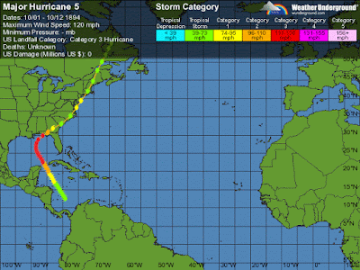
In October of 1894, a hurricane struck northeast Florida and crossed
into southern and central Georgia, and became a a tropical storm. There
is no real data to indicate if the storm was a full hurricane strength as it
passed near Laurens County.

Path of the 1894 Hurricane

Path of the 1898 Hurricane
J.A. Falk, assistant superintendent of the Jekyll Island Club, reported that "we had the most severe storm ever known here - it was a tidal wave." The dunes along the beach were washed away. The fisherman's houses and the northern and southern ends of the island were washed away. The village of millionaire's cottages survived the storm virtually unharmed, despite the fact that the entire island was covered with water and many oaks were blown down.
Cumberland Island, now thought to be the site of the landfall of the eye of the hurricane, was subjected to vicious winds, heavily rainfall, and a high storm surge. Frank Fader's pilot boat was found on a bluff twenty feet above the high water level. Many homes, especially along the northern end of the island, were destroyed.
Fernandina Island, to the south, was completely covered with water. Almost everything not tied down was swept away. Not a single church in Old Town Fernandina survived the onslaught.

In East Central Georgia, the winds began to pick up late in the evening of October 2nd. Damage reports came in from all over southeastern Central Georgia. The "Montgomery Monitor" reported that "one could not look in any direction without seeing evidences of the storm's devastation, or walk more than a foot without encountering them." The entire cotton crop was damaged in Montgomery County, with the sugar cane fairing only slightly better. Travel in and out of Mt. Vernon was suspended due to fallen limbs on every major thoroughfare. In Lumber City, the cotton was damaged along with the remaining fall crops. Many roads were washed out or covered with trees, limbs, and debris.
In Cochran, where a gale of such force had not been seen in a quarter of a century, farmers reported that the entire cotton crop was ruined, and the sugar cane and corn crops had suffered greatly. Many people sat up during the night fearing for their lives and property. Countless trees were destroyed and many buildings in town and in the county were damaged.
Dodge County farmers faired a little better. Only half of their cotton crop was lost. In Hawkinsville and Abbeville, farmers reported similar destruction of the cotton crop. Unfortunately, since there are no surviving Dublin newspapers from the time, there are no direct accounts of the storm's damage, which most likely would have been similar to other counties in the area.
Throughout Middle Georgia, five or more of inches of rain was measured.The storm still packed a powerful punch when it struck Macon. Although there was no thunder and lightning, one observer described the tempest as "a rain blizzard of the fiercest character, such as the oldest inhabitant has rarely seen." The damage was surprisingly light, though H.N. Burke, a trolley conductor, was electrocuted during the storm.
Twentieth Century studies of archival data have concluded that the eye of the storm may have passed thirty miles more to the south than was originally thought. With a pattern of increasing storm surges, which peaked on Jekyll Island at 19 feet, it appears likely that the hurricane made landfall on Cumberland Island. It then passed on to the northwest before becoming a tropical storm in Peach County. The remnants of the storm continued to move to the northwest, making a large loop around Illinois and Indiana before turning to the northeast and returning to the Atlantic Ocean in northern Massachusetts.
On August 11, 1940, a Category 1 hurricane struck and devastated Savannah head on from east to west. The storm, diminishing as it traveled west along Highway 80, still retained high tropical storm winds, enough to kill a reported total of 258 dead sparrows around the Federal building on the Courthouse Square in Dublin. Except for many trees and tin roofs being ripped off, there was no widespread severe damage reported. Weather observer J.L. Flanders reported 6.17 inches of rain from the storm and a corresponding one- day, nine-foot rise in the level of the Oconee River. City street workers and farmers around the county spent several days cleaning up fallen trees, limbs and debris.
Category 3 hurricanes Hugo (1989) and Floyd (1999) were near misses moving just to the northeast of Savannah at the last
moment.
With today’s technology, meteorologists can study the projected paths of Hurricane for up to a week in advance. Early warning systems and
evacuation programs now in place, were not available. Let us all hope that the disastrous hurricanes of the late 1800s will never return in
anyone’s lifetime. Everyone pray that Hurricane Irma is kind to us as well.
(This is an edited version of a column from a previous issue of the Courier Herald.)
Comments
https://www.weather.gov/media/tbw/paig/PresAmHurricane1910.pdf